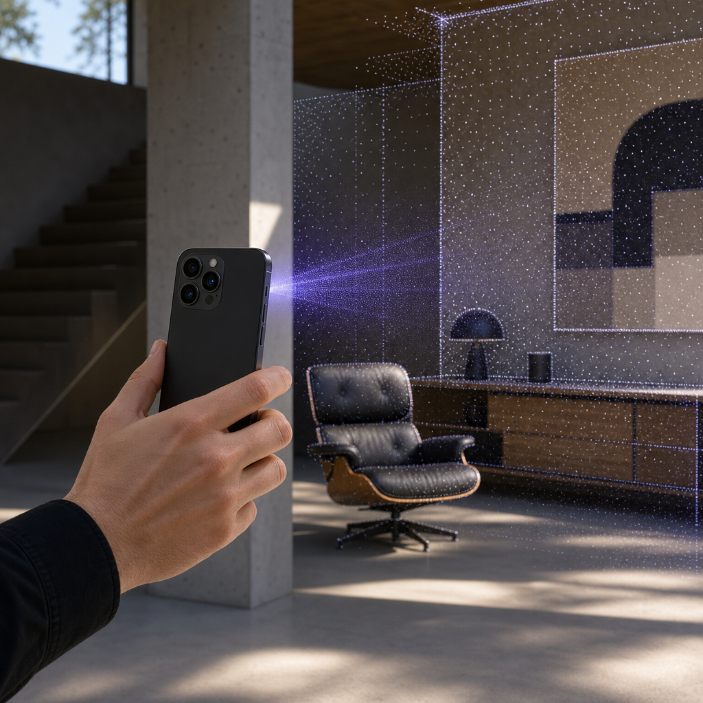
The iphone lidar scanner already living inside your iPhone 12 Pro or later is a genuine depth-sensing instrument, not a novelty tucked behind a camera app. Apple ships a laser array on the back of every Pro model that measures distance by timing reflected light, and it captures a scene fast enough to reconstruct rooms, parts, and products in seconds. What most people never do is point that hardware at real professional work. Voxelio exists to close that gap. It turns the sensor into a capture tool that exports textured meshes, colored point clouds, and frame-accurate camera poses directly on your device, without shipping a single frame to a server.
The distinction matters because the scanner is only half the system. Raw depth samples need reconstruction, texturing, scale consistency, and file formats your downstream software can actually open. Voxelio handles that pipeline with four capture modes built around ARKit mesh reconstruction and custom spatial fusion, and it does so as a free download with no subscription. If you have the right iPhone, you already own the sensor. This article explains what that sensor can do, how Voxelio's four modes translate it into usable data for different professions, and how to decide whether it fits your work.
Table of contents
- What the iPhone LiDAR sensor actually measures
- Voxelio's four capture modes and who each one serves
- Accuracy, range, and the capture envelope
- A realistic capture-to-export workflow
- Cost, ownership, and where Voxelio fits
- Frequently asked questions
What the iPhone LiDAR sensor actually measures
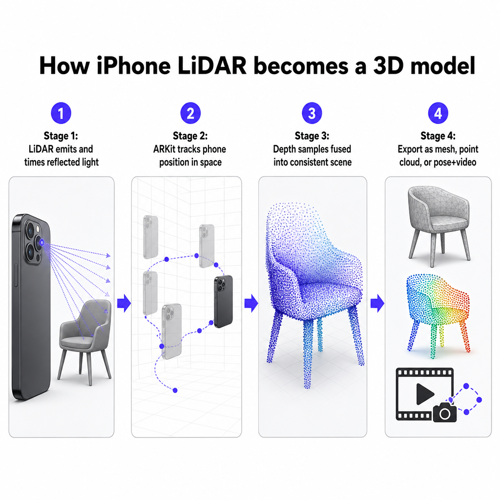
LiDAR works by emitting light and measuring how long it takes to bounce back, which yields a distance for each sampled point. Apple introduced this sensor on the iPhone 12 Pro and has carried it forward on every Pro generation since. On iPhone the sensor primarily supports augmented reality, scene understanding, and plane detection, but the same depth stream feeds room scanning, floor plan generation, interior design capture, construction site documentation, volume estimation, and object scanning. That range of documented uses is why treating iPhone LiDAR as a serious measurement device is defensible rather than optimistic.
The sensor alone produces depth data, not a finished model. To become useful, those samples must be fused into a consistent spatial structure, aligned to a stable scale, and either meshed or preserved as points. This is where an app's reconstruction engine determines the quality of the result. Voxelio pairs the LiDAR feed with ARKit, which tracks the phone's position in space as you move, so depth samples captured from different angles fuse into one coherent scene rather than a pile of disconnected snapshots. The reconstruction happens on the device itself, which keeps your data private and removes any dependency on a network connection during fieldwork.
If you want the conceptual grounding before going deeper, Voxelio's beginner's guide to what a 3D scanner is walks through how LiDAR, meshes, and point clouds relate to one another and where a phone-based scanner sits among the wider family of capture hardware. That background helps clarify why the export format you choose matters as much as the scan itself.
Voxelio's four capture modes and who each one serves
Voxelio's capture modes are the core of the product because each one produces a different data type for a different downstream job. Choosing the right mode before you start walking is the single decision that most affects whether your scan is usable.
Mesh mode for spaces and visualization
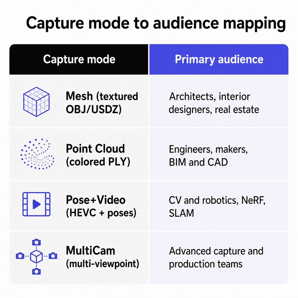
Mesh mode uses ARKit mesh reconstruction to build a continuous surface of a space or object and exports textured meshes in OBJ and USDZ. Texturing relies on keyframe texture baking, meaning the app selects representative camera frames and bakes them onto the model's UVs so the surface carries realistic color and detail rather than flat shading. For architects, interior designers, and real estate professionals, this is the mode that produces a walkable, visually faithful record of existing conditions. iPhone LiDAR already supports dimensioned floor plans, 3D room scans with depth, and point clouds for building information modeling when paired with capable software, and Mesh mode is Voxelio's route to that first category of output. If your project centers on buildings specifically, the walkthrough in how to create a building 3D model with your iPhone LiDAR scanner covers the spatial capture approach in more depth.
Point Cloud mode for engineering and BIM
Point Cloud mode fuses depth samples into a spatially consistent point cloud through point cloud fusion and exports colored PLY. Unlike a mesh, a point cloud preserves the raw geometry as discrete measured points, which is what CAD, BIM, reverse-engineering, and scientific workflows often prefer as a starting layer. LiDAR is broadly established across architecture, engineering, and construction for planning, technical documentation, budgeting, maintenance, reconstruction, and progress monitoring, and smartphone-based systems have been shown to contribute to high-resolution mapping and object imaging. Engineers and makers can bring Voxelio's PLY output into their existing tools as reference geometry for room-scale spaces or medium-sized parts, keeping in mind the sensor's practical envelope discussed below.
Pose+Video mode for CV and robotics
Pose+Video mode records HEVC video alongside frame-accurate camera pose data, which is precisely the pairing that neural radiance field reconstruction, simultaneous localization and mapping, and photogrammetry pipelines require. These methods need synchronized RGB frames and a known camera trajectory to reconstruct scenes or train models, and getting reliable pose data is usually the hard part. Computer vision and robotics researchers can treat Voxelio as the acquisition front end for their pipelines, capturing the trajectory and imagery in one pass. Smartphone LiDAR already has documented utility in geosciences and indoor mapping, which supports its credibility as a research acquisition tool rather than a toy.
MultiCam mode for richer coverage
MultiCam mode captures from multiple viewpoints for broader coverage of a subject and follows the same local, data-rich export philosophy as the other modes. The exact synchronization method and the maximum number of devices are not fully specified in the current product information, so treat MultiCam as the advanced-coverage option for production teams and verify the specifics for your setup before committing to a multi-device shoot. The value proposition is consistent with the rest of the app: outputs stay on-device and slot into the same OBJ, USDZ, PLY, and pose workflows.
Accuracy, range, and the capture envelope
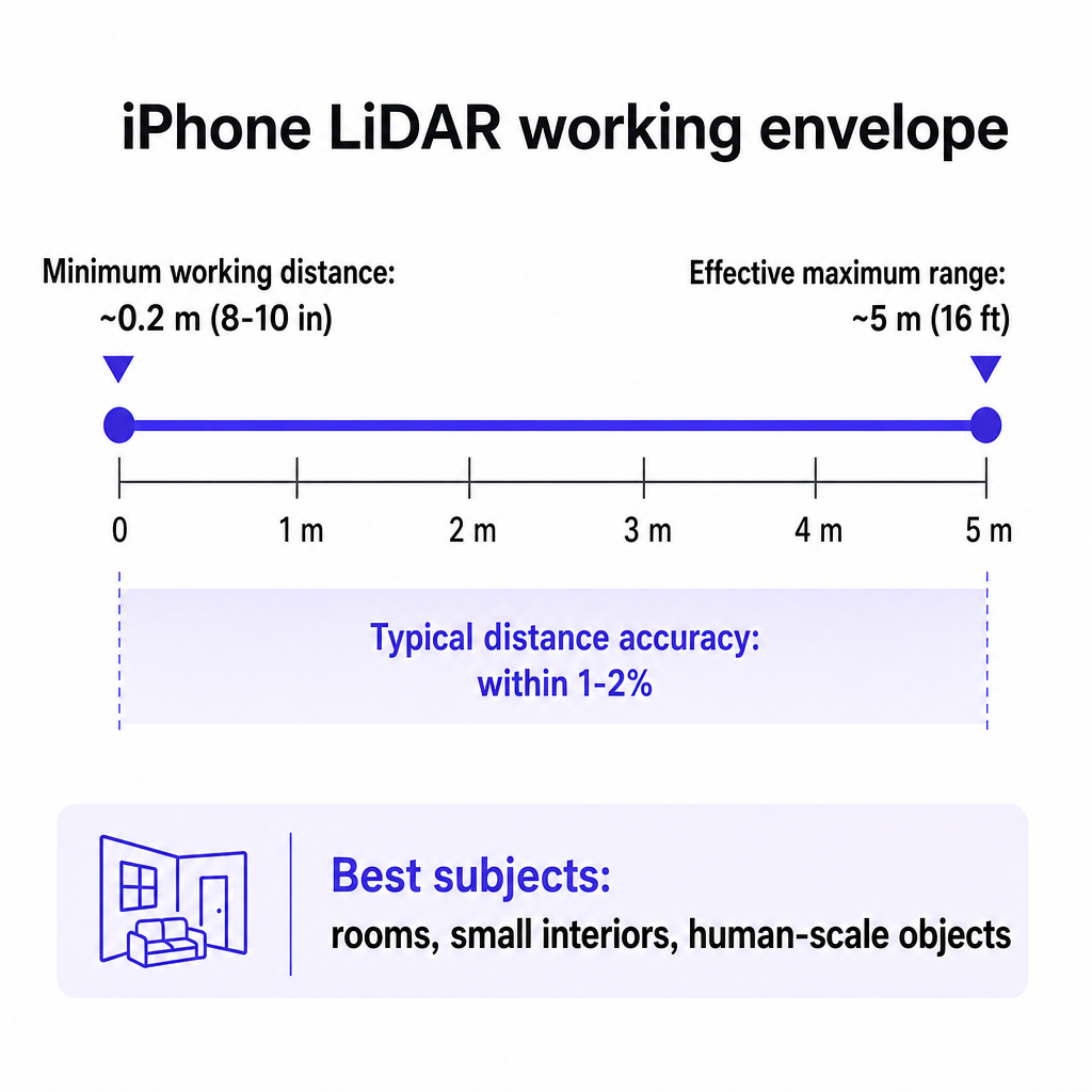
Honest capture planning starts with the sensor's physical limits. Under normal conditions iPhone LiDAR measurements typically fall within one to two percent of actual distance, which aligns with Voxelio's centimeter-level positioning for many practical scenarios. The effective maximum range is roughly five meters, about sixteen feet, with a minimum working distance around eight to ten inches. Those numbers define what the hardware does well and where it struggles.
The practical consequence is that iPhone LiDAR with Voxelio is strongest for rooms, small interiors, and human-scale objects. Very large outdoor structures push beyond the sensor's reach and generally require multi-pass strategies rather than a single sweep. A study evaluating the iPhone 12 Pro LiDAR for geosciences concluded that despite its range limitations, the device's versatility in handling makes Apple LiDAR a cost-effective alternative to established remote sensing techniques across multiple fields. That framing is the right way to think about the envelope: it is a capable instrument within its working distance, not a terrestrial survey scanner.
For measurement, a one-to-two-percent tolerance is well suited to conceptual design, documentation, and reference geometry. It is not a substitute for high-precision survey work where sub-centimeter certified accuracy is required. Being explicit about this protects your deliverables. A Voxelio scan can anchor a design proposal, a fabrication reference, or a research dataset with confidence, while a legal survey or a safety-critical structural measurement still belongs to specialized instruments. Voxelio's centimeter-level precision claim is consistent with the external accuracy evidence, though app-specific calibration figures and maximum scene sizes are best confirmed for your particular use.
A realistic capture-to-export workflow
The on-site process is fast, which is one of the sensor's real advantages. A typical room can be captured in roughly thirty to sixty seconds on a LiDAR-equipped iPhone, and Voxelio is built around walk-through durations in that range. The steps are straightforward once you have selected the right mode for your intended output.
Begin by confirming you have a compatible device, since LiDAR exists only on iPhone 12 Pro and later Pro models. Open Voxelio and choose your capture mode based on what you need downstream: Mesh for a textured visual model, Point Cloud for measured geometry, Pose+Video for a CV pipeline, or MultiCam for multi-viewpoint coverage. Move deliberately around the subject, keeping within the sensor's working range and maintaining steady overlap so ARKit can track your position and fuse the samples cleanly. Cover surfaces from more than one angle where you can, because texturing and geometry both improve with varied viewpoints.
When capture finishes, reconstruction and export happen on the device. Mesh mode delivers textured OBJ or USDZ, Point Cloud mode delivers colored PLY, and Pose+Video mode delivers HEVC video with per-frame camera poses. Those formats map directly to standard downstream software. USDZ opens in the Apple ecosystem and AR Quick Look, OBJ and PLY import into CAD, BIM, and 3D tools such as the ones architects and engineers already run, and the pose data feeds custom computer vision code. Because nothing uploads, you can complete an entire capture and export cycle in the field with no signal.
The key planning habit is matching format to destination before you scan, not after. An e-commerce seller who wants an AR-viewable product listing should capture in a mode that yields USDZ, while an engineer building reference geometry wants the point cloud. Choosing correctly up front saves a return trip to the subject. For a value-focused perspective on why this workflow replaces far more expensive hardware for many teams, Voxelio's argument that the cheapest 3D scanner in 2026 is already in your pocket lays out the cost comparison in detail.
Cost, ownership, and where Voxelio fits
The economic case is direct. Dedicated terrestrial laser scanners and structured-light systems typically cost far more than a phone, and independent evaluation supports treating iPhone LiDAR as a cost-effective alternative for many tasks. Voxelio is free to download with no subscription required, so for anyone who already owns a compatible Pro iPhone, the marginal cost of entering professional 3D capture is effectively zero. That combination is especially compelling for freelancers, small studios, and research groups that cannot justify a five-figure scanner for room-scale work.
Where Voxelio fits depends on your subject and your tolerance. For architects, designers, and real estate professionals documenting interiors, it produces textured models and dimensioned records fast enough to fit into a site visit. For engineers and makers, it supplies point clouds and meshes as reference geometry for parts and spaces within a few meters. For e-commerce sellers, it converts physical products into USDZ models viewable in AR, reducing dependence on studio photogrammetry setups. For CV and robotics researchers, it captures the synchronized imagery and camera trajectory that reconstruction pipelines depend on. And for hobbyists and 3D printing enthusiasts, it turns real objects and workspaces into fabrication references without any recurring fee.
A few details remain worth confirming for your own planning. Export resolution limits such as mesh triangle counts and point density, maximum recommended scene size, on-device processing times, the full MultiCam workflow, and any specifics of the free model are all best verified directly rather than assumed. Android support is planned but not yet available, so today the app is an iOS tool tied to LiDAR-equipped Pro hardware. When scanning occupied or private spaces, respect property owner consent and the privacy of anyone present as a matter of professional practice.
The practical starting move is simple. Confirm your iPhone is a 12 Pro or newer, install Voxelio, and run a test capture on something familiar such as your living room, a product on a shelf, or a workshop bench. That single scan will tell you more about fit than any specification sheet, because you will see the exact mesh, point cloud, or pose data your own subject produces.
Frequently asked questions
Which iPhones work with Voxelio?
Voxelio requires the built-in LiDAR sensor, which Apple includes only on Pro models starting with the iPhone 12 Pro and continuing through later Pro generations. Standard, non-Pro iPhones lack the sensor and cannot run LiDAR capture. Android support is planned but not yet available, so the app is currently an iOS tool tied to LiDAR-equipped Pro hardware.
How accurate are Voxelio scans?
Under normal conditions iPhone LiDAR measurements typically fall within one to two percent of actual distance, which supports Voxelio's centimeter-level positioning for many practical uses. That precision suits conceptual design, documentation, fabrication references, and research datasets. It is not a replacement for certified high-precision survey instruments where sub-centimeter accuracy is legally or structurally required.
What file formats can I export?
Mesh mode exports textured OBJ and USDZ, Point Cloud mode exports colored PLY, and Pose+Video mode exports HEVC video with frame-accurate per-frame camera poses. These formats open directly in common CAD, BIM, 3D, and AR tools, and USDZ works with AR Quick Look in the Apple ecosystem. All exports are generated entirely on the device.
Does Voxelio need an internet connection or cloud account?
No. Reconstruction and export happen entirely on-device, so you can capture and export in the field without a network connection. Nothing is uploaded to a server for processing, which also keeps your captured spaces and objects private to your device.
What size spaces or objects can it scan well?
The iPhone LiDAR sensor has an effective range of roughly five meters and a minimum working distance around eight to ten inches, making it strongest for rooms, small interiors, and human-scale objects. Very large outdoor structures exceed the sensor's reach and generally require multi-pass approaches rather than a single capture.
Is Voxelio really free?
Voxelio is free to download with no subscription required. Details such as export quotas or in-app purchases in the free model are best confirmed directly, but the core positioning is a no-subscription entry point into professional 3D capture for anyone who already owns a compatible Pro iPhone.