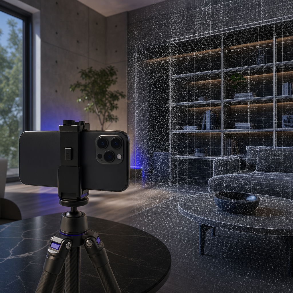
If you own an iPhone 12 Pro or later, a centimeter-accurate 3D scanner is already sitting in your pocket. The LiDAR sensor Apple built into its Pro devices does the same core job as depth hardware that used to cost thousands of dollars: it measures the distance to real surfaces and lets software rebuild them as usable 3D data. What has been missing for most people is the software layer that turns that raw depth stream into files a CAD program, game engine, product page, or research pipeline can actually read. That is the gap the Voxelio iphone lidar scanner app is built to close, capturing spaces and objects with ARKit and exporting textured 3D models, point clouds, and camera pose data entirely on-device.
This is not a demo toy. Voxelio uses ARKit mesh reconstruction, spatial point cloud fusion, and keyframe texture baking to produce professional data products — textured OBJ/USDZ meshes, colored PLY point clouds, and HEVC video with frame-accurate camera poses — without sending your building interiors or product images to a cloud server. The app is free to download with no subscription, which means the entire cost of a working 3D capture setup collapses to hardware you likely already carry for calls and photos.
Table of contents
- What the LiDAR scanner in your iPhone actually measures
- Does your iPhone already qualify as a pro 3D capture tool
- How Voxelio turns LiDAR depth into professional files
- Choosing a capture mode by the file your workflow needs
- Where iPhone LiDAR scanning fits — and where it does not
- Running your first controlled scan with Voxelio
- Frequently asked questions
What the LiDAR scanner in your iPhone actually measures
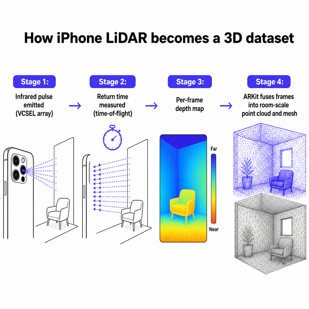
LiDAR is a time-of-flight system. The sensor emits pulses of non-visible infrared light, then measures how long each pulse takes to bounce off a surface and return. Because the speed of light is constant, that round-trip time converts directly into distance. iFixit's teardown-level explanation frames it plainly: the iPhone bounces infrared light off objects and times the return to compute how far away each point is.
The iPhone implementation is a direct time-of-flight sensor built around a VCSEL array that fires structured infrared pulses. Technical guidance written for property inspectors describes how the sensor produces sparse depth maps, and how ARKit fuses successive frames into a denser, room-scale point cloud as you move the device. That fusion step is the difference between a single blurry depth snapshot and a coherent 3D reconstruction of an entire room.
Apps reach this data through ARKit's depth APIs, which expose per-frame depth alongside the camera image and device motion. Voxelio combines all three signals — LiDAR depth, camera frames, and device motion from the phone's inertial sensors — to build mode-specific source data directly on the iPhone. The camera supplies color and texture, the LiDAR supplies metric distance, and the motion data keeps everything spatially registered as you walk around a space.
The practical takeaway for a buyer is that this is genuine metric capture, not a photographic trick. When you scan a room, you are recording real dimensions, not just an image that looks three-dimensional. That is why the output can drive measurements, CAD reference geometry, and AR product previews rather than only pretty renders.
Does your iPhone already qualify as a pro 3D capture tool
The hardware gate is non-negotiable, and it is simple: LiDAR-based capture requires an iPhone 12 Pro or a later Pro model, plus certain recent iPad Pro generations. The sensor lives only in Pro devices. A standard iPhone can run ARKit for augmented reality overlays, but without the LiDAR module it cannot capture the on-device depth geometry that this workflow depends on, regardless of which app is installed. A developer account of building LiDAR apps with ARKit independently confirms the same boundary: only Pro iPhones from the 12 Pro onward and recent iPad Pros include the sensor.
That single fact reframes the entire cost conversation. A terrestrial laser scanner is a dedicated purchase in the many-thousands-of-dollars range. Voxelio's cost analysis points to an indoor mapping study in which Apple LiDAR devices produced 3D models with centimeter-range error against a terrestrial laser scanner, and estimates that an iPhone Pro paired with a free on-device app reaches that accuracy at roughly 2.5% of the cost of the dedicated scanner. If you already own the phone for other reasons, the marginal cost of adding professional 3D capture is effectively the download.
To check eligibility quickly, confirm your device is a Pro model from the iPhone 12 Pro generation or newer. If it is, the depth hardware is present and the only remaining variable is the software you point at it. For readers who want the full sensor rundown before committing, our explainer on what the LiDAR scanner in your iPhone can actually do walks through the models, range, and accuracy in more detail.
Android support is planned but not yet available, so for now this is an iPhone and iPad Pro workflow. That constraint is worth stating plainly rather than glossing over, because it determines whether the rest of this article is immediately actionable for you or a note for a future device.
How Voxelio turns LiDAR depth into professional files
Raw depth maps are not useful on their own. The value comes from what the software does with them, and Voxelio's differentiators all live in that processing layer. ARKit mesh reconstruction converts the fused point cloud into a continuous surface. Spatial point cloud fusion aligns depth samples from many frames into one coherent, colored dataset. Keyframe texture baking selects representative camera frames and projects their color onto the geometry so the finished model carries realistic surface detail rather than a flat gray shell.
Every one of these steps runs locally on the device. There is no cloud account to create and nothing to unlock before you export. For professionals scanning building interiors or unreleased products, that on-device model removes two recurring headaches at once: per-project cloud processing fees, and the data-residency and confidentiality questions that come with uploading a client's floor plan or a proprietary product to a third-party server.
The Mesh mode is the clearest example of the output philosophy. It produces an OBJ mesh, an MTL material file, and an optional texture atlas or photo textures, and lets you export the mesh as classification-colored, neutral, or real-color output. Texture quality scales with the scene, the lighting, and the Lo-Fi, Mid, or Max quality setting you choose, so you can trade capture speed against surface detail depending on whether you need a quick spatial reference or a presentation-grade model.
Because the geometry carries real metric scale, the files drop into downstream tools without a guessing game about units. An OBJ from a room scan opens at the correct size in a modeling package; a colored PLY point cloud carries usable coordinates into CAD or BIM. That fidelity is what separates a professional capture tool from a novelty scanner that produces good-looking but dimensionally unreliable meshes.

Choosing a capture mode by the file your workflow needs
Voxelio offers four capture modes, and the right choice is decided by the file your downstream tool wants — not by which mode sounds most advanced. Each mode is engineered around a different output and a different professional need.
| Capture mode | Primary output | Best fit |
|---|---|---|
| Mesh | OBJ + MTL, optional texture atlas | Rooms, product models, watertight geometry |
| Point Cloud | Colored PLY point cloud | CAD, BIM, point-based measurement |
| Pose+Video | HEVC video + frame-accurate camera poses | NeRF, SLAM, photogrammetry pipelines |
| MultiCam | Multi-view capture | Richer geometry and research datasets |
For an architect or interior designer, Mesh mode captures a room as textured OBJ geometry for planning and visualization, while Point Cloud mode gives a colored PLY that slots into a BIM or CAD environment for measurement. The choice depends on whether you need a surface to present or coordinates to measure against.
A maker or engineer typically reaches for Mesh mode to pull an existing object into CAD as reference geometry, or as a starting point for a 3D-printable model. An e-commerce or marketplace seller replacing flat photos wants a textured mesh or USDZ model that can sit on a product page and drive an AR preview, so keyframe texture baking and real-color output matter most.
Computer vision and robotics researchers are the audience for Pose+Video and MultiCam. Pose+Video exports HEVC video alongside frame-accurate camera poses, which is exactly the input a NeRF trainer, SLAM system, or photogrammetry pipeline needs. MultiCam extends this to multi-view capture for more robust reconstructions and richer research datasets. If you are weighing which app fits a specific role, our comparison of the best iPhone 3D scanner app for architects, makers, and e-commerce sellers lines the personas up against the modes and exports each one actually uses.
Where iPhone LiDAR scanning fits — and where it does not
Honest scope is what makes this a professional tool rather than a marketing claim. iPhone LiDAR with Voxelio is genuinely strong for documentation, design reference, visualization, and AR — rooms and mid-sized objects reconstruct reliably at centimeter-level accuracy. A peer-reviewed characterization of iPhone LiDAR sensing reports absolute accuracy on the order of one centimeter for objects a few meters in size, which matches the indoor mapping results Voxelio cites.
The limits are equally concrete. LiDAR struggles with thin edges, glass, and dark, light-absorbing materials, because those surfaces either return too little signal or scatter it unpredictably. Tech commentary on iPhone LiDAR makes the same point about output quality: the meshes are an excellent starting point with accurate proportions, but they usually need cleanup before high-end 3D printing or precision manufacturing. Expect to spend time in a modeling tool if your end goal is a tight-tolerance part.
The most important boundary is the difference between centimeter-level and survey-grade. This workflow is not a substitute for millimeter-accurate metrology hardware, and it should not be presented as one where a project or regulation demands certified survey measurements. Where those requirements exist, treat the iPhone scan as fast, low-cost documentation that complements — not replaces — dedicated survey equipment.
There is also a practical courtesy layer worth naming. Scanning building interiors or products can involve client confidentiality, intellectual property, and site-specific or contractual rules about what you may capture. On-device processing keeps the data off third-party servers, which helps, but you should still respect any restrictions that apply to a given space or object. This is general good practice, not legal advice, and specific situations deserve case-specific verification.
Understanding these boundaries is what lets you position the tool correctly to a client. Voxelio plus a Pro iPhone is a low-risk, low-friction way to add 3D to workflows that previously could not justify dedicated hardware or a recurring scanning subscription — used carefully, within its accuracy envelope.
Running your first controlled scan with Voxelio
Getting from download to a usable file is a short, repeatable sequence. The discipline is in the capture technique, not the button presses.
- Confirm your device has LiDAR — an iPhone 12 Pro or later Pro model, or a supported iPad Pro. This is the hardware gate that everything else depends on.
- Install Voxelio. It is free, requires no subscription or account, and exports are available immediately with nothing to unlock first.
- Choose the mode by your downstream file: Mesh for textured geometry, Point Cloud for CAD and BIM, Pose+Video or MultiCam for research pipelines.
- Run a controlled first scan. Work in good, even lighting, avoid reflective and transparent surfaces where possible, move steadily and methodically to stay within workable tolerance, and pick a quality setting that matches your detail needs — Lo-Fi for speed, Max for presentation-grade texture.
- Export into your existing tools: a modeling package or slicer, a CAD or BIM environment, a game engine or 3D viewer, or a NeRF trainer.
The single biggest quality lever is capture behavior. Steady, complete coverage — walking a room once slowly and deliberately rather than sweeping the phone quickly — keeps the fused geometry clean and reduces the cleanup you face later. Reflective glass, mirrors, and dark matte surfaces are the usual sources of holes and noise, so plan your path to cover the surfaces that matter most while accepting that the difficult ones may need manual repair.
If 3D scanning is new to you and you want the underlying concepts before your first capture, our complete beginner's guide to 3D scanners covers the terminology and workflow ideas that make the mode choices above easier to reason about.
Frequently asked questions
Which iPhones can run the Voxelio LiDAR scanner?
LiDAR-based capture requires an iPhone 12 Pro or a later Pro model, and certain recent iPad Pro generations, because only those devices include the LiDAR sensor. Standard, non-Pro iPhones can run ARKit but lack the depth hardware needed for on-device 3D capture. Android support is planned but not yet available.
How accurate is iPhone LiDAR scanning?
Independent research and indoor mapping studies place iPhone LiDAR reconstruction at centimeter-level accuracy — on the order of one centimeter for objects a few meters in size. That is sufficient for documentation, design reference, visualization, and many indoor mapping tasks, but it is not survey-grade or millimeter-accurate metrology. Results vary with lighting, surface type, and how steadily you capture.
What file formats does Voxelio export?
Mesh mode exports an OBJ mesh with an MTL material file and optional texture atlas or photo textures, with classification-colored, neutral, or real-color output. Point Cloud mode exports colored PLY point clouds. Pose+Video mode exports HEVC video with frame-accurate camera poses. These map to CAD, BIM, game engines, 3D viewers, USDZ-based AR previews, and NeRF or SLAM pipelines.
Does Voxelio need a cloud account or subscription?
No. Voxelio is free to download with no subscription and no cloud account. All processing — mesh reconstruction, point cloud fusion, and texture baking — runs on-device, so there is nothing to unlock before you export and your scans of interiors or products are not uploaded to a third-party server.
Which capture mode should I choose?
Choose by the file your downstream tool needs, not by which mode sounds most advanced. Use Mesh for textured geometry and product or room models, Point Cloud for CAD and BIM measurement work, and Pose+Video or MultiCam for research pipelines like NeRF, SLAM, or photogrammetry that require camera pose data.
Can I use iPhone LiDAR scans for 3D printing?
Yes, as a starting point. Mesh scans have accurate proportions and export cleanly as OBJ geometry, but meshes typically need cleanup before high-end 3D printing or precision manufacturing, and thin edges, glass, and dark absorbent surfaces can introduce noise. Expect some modeling work if your target is a tight-tolerance printed part.