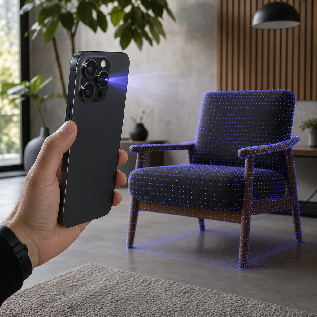
The LiDAR scanner sits quietly in the rear camera cluster of every iPhone Pro since the 12 Pro, and most people who own one have never used it for anything more demanding than a slightly faster portrait focus in low light. That is a waste of hardware. If you want to understand what is lidar scanner in iphone terms that actually matter, the honest answer is this: it is a depth sensor that measures distance by timing pulses of light, and with the right app it converts a room or an object into a precise 3D mesh, a colored point cloud, or a stream of frame-accurate camera poses — all processed on the device, no cloud round-trip required.
That last part is where Voxelio comes in. Voxelio is a free iPhone LiDAR 3D scanner built on Apple's ARKit stack, and it exists to turn the sensor you already paid for into a working capture tool for architecture, fabrication, e-commerce, and computer-vision research. So this article does two things. First, it explains the sensor honestly: which iPhones have it, how far it reaches, and how accurate it really is. Then it pivots to the question that pays for itself — which of your current workflows can an iPhone Pro plus Voxelio realistically replace in 2026.
Table of contents
- What the iPhone LiDAR scanner actually is
- Which iPhones have LiDAR, and why non-Pro models are excluded
- Range, accuracy, and the physical limits you plan around
- What LiDAR plus Voxelio can do across four workflows
- On-device processing, free pricing, and why they matter
- A first production workflow, from device check to export
- Frequently asked questions
What the iPhone LiDAR scanner actually is
LiDAR stands for light detection and ranging. The scanner emits pulses of infrared light, measures how long each pulse takes to bounce back, and uses that timing to build a depth map of everything in front of the camera. On the iPhone Pro it is a small black sensor sitting near the main lenses in the rear camera array — visually distinct once you know to look for it.
On its own, the sensor is just raw depth data. The useful part happens in software. Apple exposes LiDAR through ARKit, and from iOS and iPadOS 13.4 onward developers can request scene reconstruction: ARKit takes the LiDAR depth readings and continuously builds a polygonal mesh of the surroundings. That mesh supports accurate surface location, object occlusion, physics-aware interactions, and surface classification. In plain terms, the phone stops guessing where surfaces are from the camera image alone and starts measuring them.
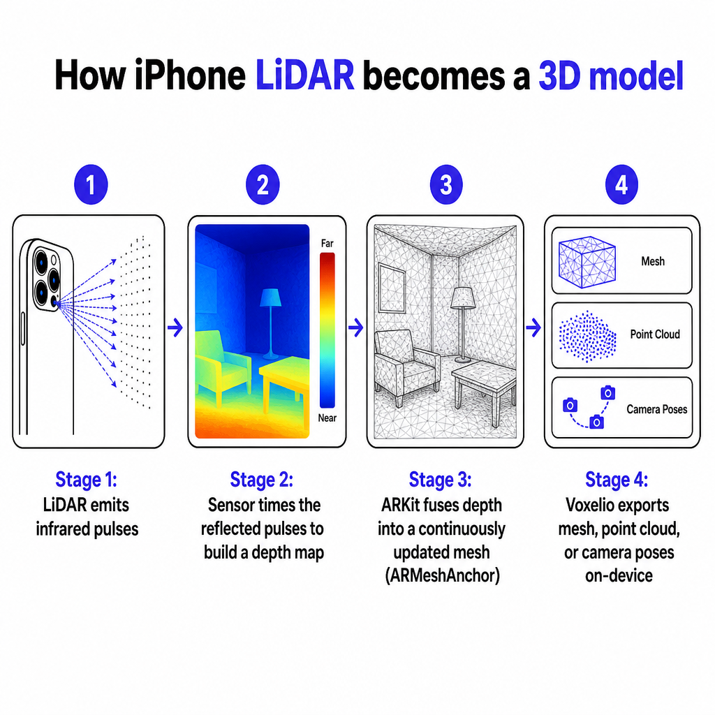
Voxelio builds directly on this pipeline. Its Mesh and Point Cloud modes consume ARKit's ARMeshAnchor data — the same mesh anchors ARKit generates from LiDAR depth — and fuse them into either a textured surface model or a colored point cloud. This is not photogrammetry, where software reconstructs geometry by matching features across many photographs. It is depth fusion built on ARKit's SLAM tracking, which means the phone knows where it is in space in real time and stitches depth readings into a coherent model as you move. The difference matters for speed, consistency, and the ability to capture featureless or dimly lit surfaces that trip up camera-only methods.
The result is a device that produces three fundamentally different data products from the same sensor: meshes for visualization and AR, point clouds for measurement, and camera pose trajectories for research pipelines. Understanding those three outputs is the key to deciding whether the scanner in your pocket can do real work.
Which iPhones have LiDAR, and why non-Pro models are excluded
LiDAR is a Pro-tier feature. It arrived on the iPhone 12 Pro and has stayed on the Pro and Pro Max models since. Standard iPhones, the Plus, the mini, and the SE do not carry the sensor. The same applies across the tablet line, where recent iPad Pro models include LiDAR while lower tiers do not. If your device is not a Pro-series iPhone or an iPad Pro, it can do camera-only AR — but it cannot do depth-based scene reconstruction, because the hardware simply is not there.
This is why Voxelio treats LiDAR as a hard requirement rather than an optional enhancement. All four of its capture modes — Mesh, Point Cloud, Pose+Video, and MultiCam — are restricted to LiDAR-equipped devices. The publisher makes this deliberate choice to keep output quality consistent: rather than shipping a degraded camera-only path on standard iPhones and letting quality vary wildly, it gates every mode behind the sensor that guarantees reliable depth. Voxelio's own documentation lists compatibility across iPhone Pro models from the 12 Pro through the 16 Pro range, plus LiDAR iPad Pro, and notes that Android support is planned but not yet shipped.
How do you confirm what you have? Check the model name in Settings, or match it against a Pro-only device list. If the box, the settings screen, or the device list says Pro or Pro Max from the 12 Pro generation onward, you have the sensor. If it says anything else, you do not — and no software will change that. For readers who want the full onboarding path from device check to first export, Voxelio's complete beginner's guide to 3D scanners walks through compatibility before anything else, because there is no point downloading a capture app your hardware cannot feed.
One practical note on future devices: Voxelio's published content explicitly covers the 12 Pro through 16 Pro range. Independent device lists extend LiDAR to each newer Pro generation as Apple releases it, but formal per-generation support statements for the very latest Pro models are best confirmed directly with the publisher rather than assumed.
Range, accuracy, and the physical limits you plan around
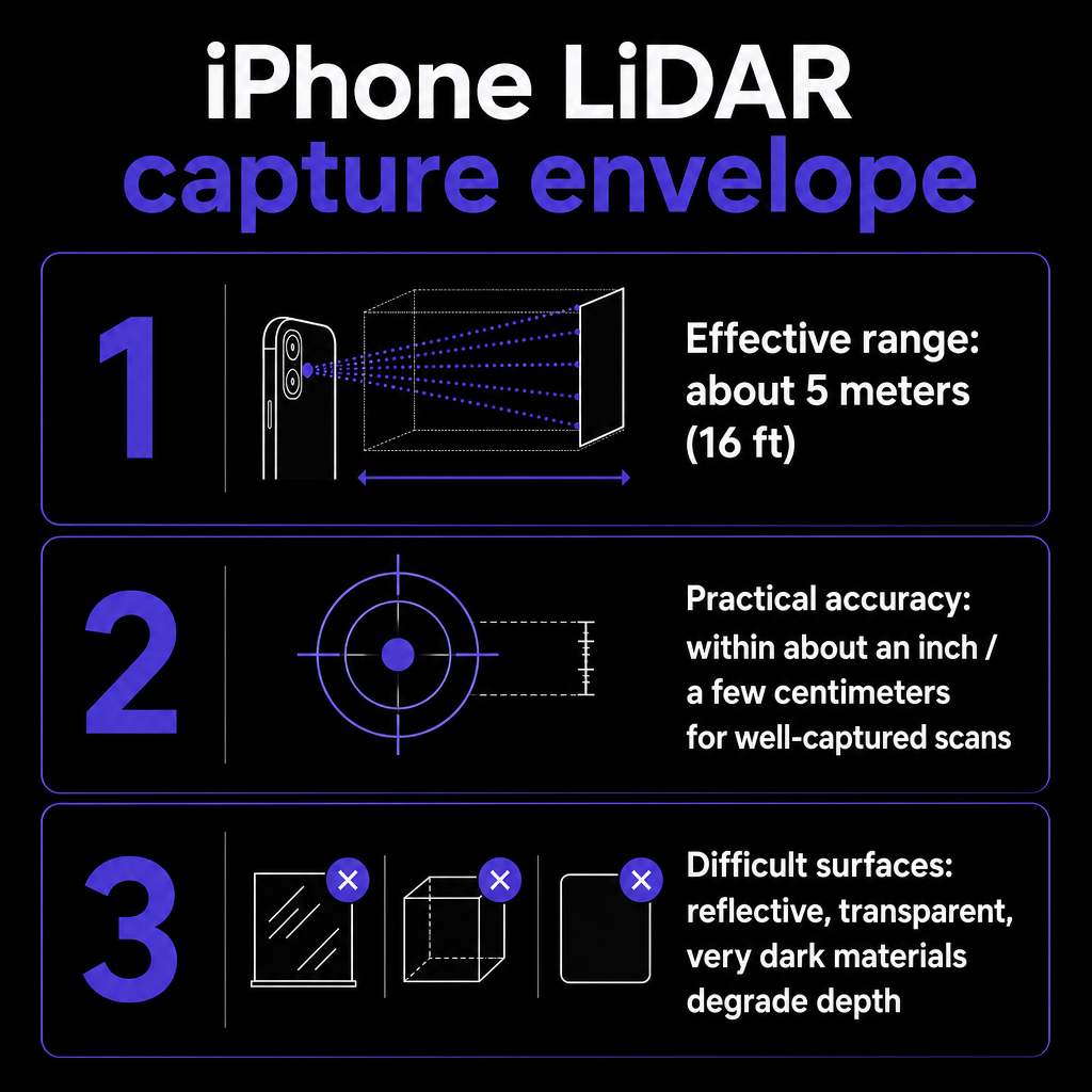
LiDAR is precise within a defined envelope, and pretending otherwise leads to disappointing scans. The iPhone LiDAR scanner has an effective maximum range of roughly 5 meters, or about 16 feet — the same figure reflected in ARKit's scene reconstruction, which builds its mesh within a radius of about 5 meters around the device. Push beyond that and depth readings fall off. This is not a flaw so much as a design boundary you plan your capture path around.
The practical consequence: you do not scan a large room by standing in the center and spinning. You walk the perimeter, keeping surfaces within range, so every wall, corner, and object passes inside the effective envelope. For a single object, you orbit it. For a mechanical part, you move close and slow. Respecting the 5-meter limit is the single biggest factor in whether a scan comes back clean or full of holes.
On accuracy, be careful with the numbers. Voxelio describes its output as centimeter-level spatial precision and a workable tolerance, and that framing is honest — it does not publish a formal specification like plus or minus a fixed figure at a given range. Independent guidance on LiDAR-based consumer scanning tools describes dimensional accuracy that typically lands within about an inch, or a few centimeters, for well-captured room-scale scenes. That is what centimeter-level means in practice for a handheld device: excellent for layout, visualization, measurement estimates, and reverse-engineering references, but not a substitute for a survey-grade instrument when a legal boundary or a machined tolerance is on the line. If you need hard accuracy figures for a specific application, validate them with your own controlled field test rather than trusting any single published claim.
Surfaces matter too. Reflective, transparent, or very dark materials scatter or absorb the infrared pulses and degrade depth readings — glass, polished metal, and black glossy plastic are the classic problem cases. First-party guidance suggests starting with matte, evenly lit objects and rooms to validate your workflow before attempting difficult materials. Get a clean scan of a cardboard box or a plaster wall first; then push into the hard cases once you trust the pipeline.
What LiDAR plus Voxelio can do across four workflows
The sensor is generic; the value is in matching its output to a real job. Voxelio structures this decision around four capture modes, each producing a different data product for a different professional workflow. Choosing the right mode before you scan saves you from re-capturing later.
Space capture for architecture, interior design, and real estate. Mesh Mode is the workhorse here. It produces textured OBJ and USDZ meshes, plus STL, of rooms and discrete objects. Those files drop into CAD, BIM viewers, and AR tools for layout studies, as-built documentation, and client-facing walkthroughs. Because ARKit tracks the device in real time, you capture an entire room by walking its perimeter within the 5-meter envelope, and the mesh assembles as you go. For a designer pricing a renovation or a real estate professional documenting a listing, this replaces a tape measure and a stack of photos with a single dimensioned model.
Fabrication and reverse engineering for engineers and makers. When the downstream job is measurement rather than visualization, Point Cloud Mode is the better fit. It outputs colored PLY point clouds — raw spatial data suited to measurement, alignment, and CAD reconstruction. A maker scanning a broken bracket to model a replacement, or an engineer capturing an existing assembly to fit new parts, works from the point cloud rather than a pre-smoothed mesh, because the raw points preserve the geometry the CAD pipeline needs. PLY, OBJ, STL, and USDZ are all standard interchange formats, so the exports flow into slicers, DCC tools, and CAD environments without conversion gymnastics.
Product visualization for e-commerce and marketplace sellers. A flat photo tells a buyer what a product looks like from one angle. A USDZ model lets them rotate it, view it at scale, and — via Apple Quick Look — place it in their own space. Mesh exports in USDZ or OBJ preview directly in Quick Look and embed in product pages as interactive 3D models. For a seller replacing photo galleries with spatial models, the LiDAR mesh is the asset that turns a listing into an experience. Voxelio's best iPhone 3D scanner app comparison frames this workflow explicitly for e-commerce sellers alongside architects and makers.
Research pipelines for CV, robotics, and SLAM. This is where Voxelio does something most iOS scanning apps do not. Pose+Video and MultiCam modes export HEVC video together with frame-accurate camera poses — the position and orientation of the camera for each frame — as JSON or CSV, plus camera intrinsics and metadata. That data feeds directly into NeRF and Gaussian Splatting training, SLAM development, and photogrammetry pipelines. Exposing per-frame camera trajectories at scale is described by the publisher as something no other iOS app offers without custom ARKit development. For a researcher building a Nerfstudio dataset, choosing JSON on export and dropping it into the pipeline replaces days of custom capture tooling. MultiCam extends this to multi-view datasets for more advanced work.
The throughline: LiDAR fundamentals — range, accuracy, depth behavior — stay constant, but the export format changes everything about who the scan serves. Pick the mode by the file your downstream tool needs, not by which one looks impressive on screen.
On-device processing, free pricing, and why they matter
Two differentiators separate an iPhone plus Voxelio from cloud-first, subscription-heavy scanning apps, and both are structural rather than cosmetic.
The first is on-device processing. ARKit and LiDAR allow mesh reconstruction and point cloud generation to happen entirely on the phone — no raw data uploaded to a server, no waiting for a cloud job to finish, no dependence on connectivity. Voxelio leans into this completely: capture, processing, and export all run locally, with no login, no account, and no upload. For field work in a basement with no signal, for a firm bound by client NDAs, or for anyone who simply does not want scans of a private interior leaving the device, the on-device path removes both the latency and the data-exposure risk of cloud reconstruction. Voxelio's explanation of SLAM 3D scanning covers how real-time on-device mapping powers this workflow without a server in the loop.
The second is pricing. Voxelio is free to download with no subscription. All four capture modes and all export formats — OBJ, USDZ, PLY, HEVC with poses — are included, with no ads and no per-scan limits. There is nothing to unlock before you can export: install, grant permissions, capture, export. This is a genuine departure from the subscription and per-scan models common among competitors, and it changes the economics for small firms and independent professionals. The publisher's own Terms do note that features and export options may vary by device and plan, so treat the current no-subscription framing as the present state rather than a permanent contractual guarantee; but the working reality today is that you can test every mode without paying anything.
Stacked together, these two points support a blunt commercial argument: for many use cases, a compatible iPhone Pro plus Voxelio is the cheapest practical 3D scanner setup available in 2026. The sensor is already bundled into a phone you likely own for other reasons. No external hardware, no dongle, no laser scanner rental, no recurring software fee. If you want to weigh what free actually covers against the fine print, Voxelio's breakdown of what 'free' really means for a 3D scanner app in 2026 is worth reading before you commit a workflow to it.
A first production workflow, from device check to export
The fastest way to know whether the LiDAR scanner earns its place in your process is to run one controlled scan end to end, then open the result in the tool you actually use. Here is the sequence the publisher recommends, adapted to a first production test.
Start by confirming your device is a LiDAR-equipped iPhone Pro or iPad Pro. Everything downstream depends on this, so do not skip it. Then install Voxelio from the App Store and grant ARKit and camera permissions at first launch; verify that files save to Photos or Files so you know where exports land.
Next, run a calibration scan before any real work. Pick a single small object or one room corner and capture it in the mode that matches your primary workflow — Mesh for rooms and products, Point Cloud for measurement, Pose+Video for research. Keep the phone steady, hold surfaces within the 5-meter range, and move deliberately. When the capture stops, review the model for holes or noise and re-scan any gaps rather than accepting a flawed first pass.
Then export in the target format and — this is the step people skip — open the file in the real downstream tool. A USDZ opens in Apple Quick Look. A PLY goes into your CAD or measurement software. An OBJ or STL loads into a slicer or DCC app. A JSON pose set drops into a NeRF pipeline like Nerfstudio; CSV suits other pipelines. Do not judge the scan by how it looks in the app's preview. Judge it by whether it does the job in your production environment. That is the only validation that counts.
Once a controlled scan clears that bar, move to production: rooms for layout documentation, product SKUs for listings, mechanical parts for fabrication, or full datasets for SLAM and NeRF research. For teams evaluating this at scale — standardizing capture across a design studio, an e-commerce catalog, or a research lab — the publisher invites direct contact for onboarding and commercial workflow questions, so internal accuracy and file-compatibility tests can be validated against your specific pipeline before rollout.
One caution worth stating plainly: none of the surfaced evidence provides jurisdiction-specific rules on scanning private property, people, or regulated environments. Treat this article as a capability guide, not legal advice. Comply with local privacy and property laws and any client NDAs or internal policies governing what you may capture, and route genuinely regulated work through your compliance team.
Frequently asked questions
Which iPhones have the LiDAR scanner?
LiDAR is limited to Pro-tier devices, starting with the iPhone 12 Pro and continuing on Pro and Pro Max models since. Standard iPhones, the Plus, mini, and SE do not have it, and neither do lower-tier iPads — only recent iPad Pro models carry the sensor. You can confirm your model in Settings or against a Pro-only device list. Voxelio requires a LiDAR-equipped iPhone Pro or iPad Pro for all four capture modes because the sensor is the non-negotiable hardware gate.
How accurate is the iPhone LiDAR scanner?
In practice, well-captured room-scale scans typically land within about an inch, or a few centimeters — what the industry calls centimeter-level precision. Voxelio describes its output in those qualitative terms and does not publish a formal plus-or-minus specification. That level of accuracy is strong for layout, visualization, measurement estimates, and reverse-engineering references, but it is not a survey-grade instrument. If a specific application demands hard accuracy figures, run your own controlled field test to validate.
What is the range of iPhone LiDAR, and how does that affect scanning?
The effective maximum range is roughly 5 meters (about 16 feet), matching ARKit's scene reconstruction radius. This shapes how you capture: instead of standing in the center of a room, you walk the perimeter so every surface stays inside the envelope, and you orbit individual objects up close. Planning your capture path around the 5-meter limit is the biggest single factor in getting clean, hole-free scans.
What files can Voxelio export, and what are they for?
Voxelio exports textured OBJ and USDZ meshes for AR, visualization, and design; colored PLY point clouds for CAD, measurement, and reverse engineering; and HEVC video with frame-accurate camera poses in JSON or CSV, plus camera intrinsics, for NeRF, Gaussian Splatting, SLAM, and photogrammetry pipelines. STL is also available for fabrication. Choose the capture mode by the file your downstream tool needs.
Is Voxelio really free, or are there hidden costs?
Voxelio is free to download with no subscription, no ads, and no per-scan limits, and all four capture modes and all export formats are included — there is nothing to unlock before you can export. The publisher's Terms do note that features and export options may vary by device and plan, so the no-subscription framing reflects the current state rather than a permanent guarantee. The only prerequisite is a compatible iPhone Pro or iPad Pro, which already includes the LiDAR sensor.
Do I need an internet connection or a cloud account to scan?
No. Voxelio captures, processes, and exports entirely on-device using ARKit and LiDAR, with no login, no account, and no upload of raw data. This makes it usable in the field without connectivity and avoids the latency and data-exposure concerns of cloud reconstruction — a meaningful advantage for work covered by client confidentiality or done in areas with weak signal.