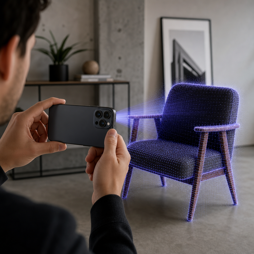
An iphone lidar scanner is a time-of-flight depth sensor built into Pro-class iPhones that fires infrared laser pulses, times their return, and measures distance from the speed of light. Paired with an app like Voxelio, that raw depth turns your phone into a precise on-device 3D scanner producing meshes, point clouds, and camera pose data. No lab, no laser tripod, no cloud upload.
That single sensor is what separates a Pro iPhone from a very good camera. A camera records color and light; the LiDAR module records geometry — how far every surface sits from the lens, dozens of times per second. When we built Voxelio around Apple's ARKit reconstruction stack, our goal was to expose that geometry as clean, exportable 3D data rather than a party-trick AR overlay. This guide explains what the sensor actually does, the kinds of 3D output it can generate, and how to judge whether it fits real architectural, engineering, e-commerce, or research work.
Table of contents
- What an iPhone LiDAR scanner is and how it works
- The four kinds of 3D output LiDAR produces
- Why iPhone LiDAR matters for your specific work
- What to weigh before you rely on iPhone LiDAR
- Where to go once you understand the sensor
- Frequently asked questions
What an iPhone LiDAR scanner is and how it works
LiDAR stands for Light Detection and Ranging. The principle is close to radar, but it uses light waves instead of radio waves, which allows far more precise distance measurement over short ranges. The sensor emits infrared laser pulses and clocks how long each pulse takes to bounce back; because light travels at a known speed, that round-trip time converts directly into distance.
On iPhone, this is a direct time-of-flight depth sensor mounted next to the rear cameras. It projects a grid of roughly 576 infrared points across the scene simultaneously, about 30 times per second, producing a live depth map — effectively a 3D depth video stream rather than a single frozen reading. Every one of those samples is a scaled distance measurement, so the phone always knows the real-world size of what it sees.
Apple introduced the rear LiDAR scanner with the iPhone 12 Pro and 12 Pro Max, and every subsequent Pro-class iPhone and iPad Pro has carried it. The practical working range is up to about five meters indoors, with accuracy on the order of a centimeter at a meter's distance and a few centimeters at room scale. Performance drops in bright sunlight, where ambient infrared adds noise to the returning pulses.
Raw depth on its own is just a cloud of distances. The value comes from what happens next. Apple's ARKit framework performs scene reconstruction: it fuses the LiDAR depth readings with the camera image and the phone's motion sensors, then applies computer vision to build a continuous polygonal mesh of the surroundings. That mesh understands walls, floors, and furniture as surfaces rather than pixels, which is what makes accurate AR placement and object occlusion possible.
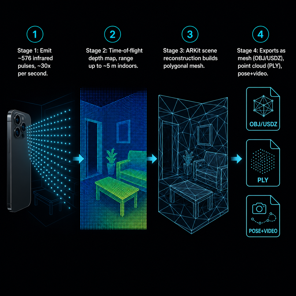
Voxelio rides directly on this stack. Where ARKit produces the underlying geometry, we add spatial point cloud fusion to merge multiple passes into one coherent, correctly scaled model, and keyframe texture baking to attach high-quality color from the camera onto that geometry. The result is a production-ready textured model computed entirely on the device, with no server round-trip. Apple's own developer documentation on capturing depth with the LiDAR camera describes the same foundation: AVFoundation exposes per-pixel depth maps that apps can combine with RGB video for reconstruction. Everything Voxelio does builds on that documented baseline.
The four kinds of 3D output LiDAR produces
People often talk about "a 3D scan" as though it were one thing. In practice the sensor can feed several distinct data types, and each supports different downstream work. Understanding the difference is the fastest way to know what you actually need.
The depth map is the rawest form: a per-frame image where each pixel encodes distance rather than color. It is the sensor's native language and the input everything else is derived from. On its own it is rarely the deliverable, but it underpins measurement and reconstruction.
A polygonal mesh is a continuous surface of connected triangles that describes solid geometry — walls, a chair, a machine part. Meshes carry texture well, look natural in AR and web viewers, and are the format most visualization and design tools expect. In Voxelio, Mesh mode uses ARKit reconstruction to produce textured meshes exported as OBJ or USDZ.
A point cloud is a dense set of individual 3D points, each with a position and often a color, with no surface connecting them. Point clouds preserve raw spatial detail and are the preferred input for many CAD, engineering, and analysis pipelines where you want measured points rather than an interpreted surface. Our Point Cloud mode fuses passes into a colored cloud exported as PLY.
A pose-plus-video stream is different again: instead of a finished model, it captures HEVC video alongside frame-accurate camera pose data — where the camera was and how it was oriented for every frame. This is the raw material for computer vision reconstruction such as NeRF and SLAM, where the algorithm rebuilds geometry from imagery and needs precise camera tracks. Voxelio's Pose+Video mode targets exactly this workflow, and MultiCam capture adds multi-camera coverage for more robust geometry and texture on complex subjects.
So the four Voxelio capture modes are not arbitrary features; they are practical realizations of these data types. Mesh and MultiCam serve finished, textured geometry. Point Cloud serves measured spatial data. Pose+Video serves research pipelines that do their own reconstruction. Choosing a mode is really choosing which representation your downstream tool consumes.
Why iPhone LiDAR matters for your specific work
The reason this technology moved from novelty to working tool is that its accuracy envelope lines up with a large band of real professional needs — not all of them, but a meaningful share.
For architects, interior designers, and real estate professionals, LiDAR enables room mapping with automatic wall and floor detection and layout capture. Independent indoor-mapping practitioners already use iPhone LiDAR to generate floor plans and 3D walkthroughs, describing it as capable of producing highly accurate 3D representations of indoor environments in real time. A textured mesh exported as USDZ drops straight into AR walkthroughs and listing viewers; the same capture can inform a measured floor plan. On-device processing also means a scan of a client's occupied home or a leased commercial floor never leaves the phone.
For engineers, makers, and fabrication, the sensor produces scaled point clouds and meshes that serve as reference geometry for CAD and 3D printing. Combined with camera imagery, LiDAR supports reverse-engineering of parts and small assemblies within centimeter-level tolerances. That is enough to model a bracket, a fixture, or a room's clearances as a working reference — provided you are not chasing machinist-grade metrology, which sits outside this precision band.
For e-commerce and marketplace sellers, LiDAR plus photogrammetry creates textured 3D product models that live in AR previews and web viewers instead of flat photos. Because Apple's ecosystem treats USDZ as the AR-ready standard, Voxelio's USDZ and OBJ exports slot directly into that pipeline, letting a seller present a product as a rotatable, placeable object.
For CV and robotics researchers, LiDAR depth combined with camera pose is a standard input for SLAM and NeRF work. Research communities in geosciences and indoor mapping already rely on iPhone LiDAR for rapid, scaled 3D capture, and OpenTopography has documented workflows that combine LiDAR geometry with photogrammetric texture for built and natural features. Voxelio's Pose+Video mode exists specifically so those pipelines get the frame-accurate poses they depend on.
Across all four groups, the through-line is the same: a device many professionals already own becomes a source of scaled, exportable 3D data without a dedicated scanner or a subscription workflow.
What to weigh before you rely on iPhone LiDAR
Good judgment here is about matching the sensor's real envelope to your tolerance for error, not about technique. A few criteria decide whether iPhone LiDAR is the right instrument for a given job.
Precision and scale. Expect centimeter-level accuracy at room scale under typical indoor conditions. For architectural layouts, interior design, product visualization, and most fabrication references, that is comfortably sufficient. For millimeter-grade metrology or survey-grade deliverables, it is not — and no amount of careful capture changes the sensor class. Treat any figure as typical performance, not a guarantee, because real results depend on the environment and how the space is covered.
Range and scene size. The roughly five-meter working range and the camera's field of view cap how much you can resolve in a single sweep. Multi-pass fusion lets you build up larger or more complex spaces, but very large or long-distance sites push past the sensor's comfortable zone. The technology is built for rooms, apartments, close-range objects, and human-scale built features rather than expansive outdoor terrain.
Lighting and surfaces. Bright direct sunlight floods the scene with infrared and degrades depth returns, so indoor and shaded conditions produce cleaner data. Highly reflective, transparent, or very dark surfaces also challenge any time-of-flight sensor. These are physics constraints, not app settings.
Output format versus destination. Decide what the receiving tool needs before you capture. Meshes (OBJ/USDZ) for visualization, AR, and e-commerce; point clouds (PLY) for CAD and analysis; pose-plus-video for research reconstruction. Capturing the wrong representation for your pipeline is the most common avoidable mismatch.
On-device versus cloud. Local processing avoids upload bandwidth, latency, and the exposure of sending building or facility data to third-party servers — which matters for commercial real estate, sensitive engineering sites, and controlled research data. Cloud services can throw heavier compute at a scan, but they introduce a dependency and a data-handling question that on-device capture sidesteps entirely.
Two misconceptions are worth retiring. First, LiDAR is not "just another camera mode"; it measures geometry directly rather than inferring it from color, which is why it produces scaled models a photograph never could. Second, it is not a drop-in replacement for a survey-grade laser scanner. It occupies a genuinely useful middle ground: far more precise and portable than photogrammetry alone, far more accessible than dedicated hardware, and accurate enough for a wide range of professional work as long as you respect its limits.
Where to go once you understand the sensor
If the sensor and its output types fit your work, the next question is practical rather than conceptual: how to actually capture a clean scan and get the right file out. For a device-and-workflow view of turning your phone into a working scanner, our guide on how to turn your iPhone into a pro 3D scanner walks through the professional capture angle for spaces and objects. If your work is camera-centric — product and creative capture — the companion piece on using your Pro camera as a 3D capture tool frames the same technology around imagery-led workflows. And for a broader look at converting the phone into a full pro 3D capture tool across export formats, that post extends the narrative into end-to-end use.
The decision in front of you is straightforward. Confirm your iPhone is a Pro model from the 12 Pro generation onward, match your deliverable to a capture mode, and check that your scene sits inside the range and lighting envelope described above. Once those three line up, Voxelio gives you the meshes, point clouds, and camera poses your workflow needs, computed on the phone in your hand.
Frequently asked questions
How accurate is the iPhone LiDAR scanner for room measurements?
Under typical indoor conditions, iPhone LiDAR reaches centimeter-level accuracy at room scale, with returns on the order of a centimeter at about a meter's distance. That is reliable enough for architectural layouts, interior design, and fabrication references. It is not a substitute for millimeter-grade metrology, and real accuracy depends on the environment and how thoroughly the space is covered, so treat published figures as typical rather than guaranteed.
What's the difference between a mesh and a point cloud?
A point cloud is a dense set of individual 3D points, each with a position and often a color, with nothing connecting them — it preserves raw measured spatial data and suits CAD and analysis. A mesh is a continuous surface of connected triangles that represents solid geometry and carries texture well, which makes it the format of choice for visualization, AR, and e-commerce. Voxelio exports meshes as OBJ or USDZ and point clouds as PLY, so you can pick the representation your downstream tool expects.
Can iPhone LiDAR replace a dedicated laser scanner?
Not for survey-grade or millimeter-tolerance work. iPhone LiDAR occupies a middle ground: far more precise and portable than photography alone, and accurate to centimeter level at room scale, but below the precision of dedicated survey hardware. For rooms, objects, product models, and most fabrication references it is a capable working tool; for high-precision metrology it is the wrong instrument class.
Which iPhones support LiDAR scanning?
Apple added the rear LiDAR scanner with the iPhone 12 Pro and 12 Pro Max, and every Pro-class iPhone since, along with iPad Pro models, includes it. Standard non-Pro iPhones do not have the sensor. Voxelio runs on iPhone 12 Pro and later, and we have Android support planned as a future roadmap item.
Is on-device scanning secure for commercial projects?
Because Voxelio processes captures entirely on the device, scan data does not leave the phone during reconstruction, which avoids upload bandwidth, latency, and the exposure of sending sensitive building or facility data to external servers. That is a meaningful advantage for commercial real estate, controlled engineering sites, and research data. Specific privacy or compliance obligations depend on your jurisdiction and the site you are scanning, so verify those against your own requirements.
What are the four Voxelio capture modes for?
Mesh mode uses ARKit reconstruction to produce textured OBJ/USDZ models for visualization and AR. Point Cloud mode fuses passes into a colored PLY for CAD and analysis. Pose+Video mode records HEVC video with frame-accurate camera poses for NeRF, SLAM, and photogrammetry pipelines. MultiCam mode adds multi-camera coverage for more robust geometry and texture on complex subjects. Each mode maps to a different downstream workflow rather than ranking against the others.