
When you ask how does arkit mesh reconstruction work, the short answer is this: your iPhone's LiDAR Scanner, RGB camera, and motion sensors feed ARKit, which converts near-field depth into a live polygonal mesh of the surfaces around you. That mesh updates in real time as you move, and it arrives already partitioned into world-anchored patches with optional semantic labels. We built Voxelio on top of exactly this pipeline, turning ARKit's live mesh into exportable, textured 3D models and point clouds that never leave your device.
The real decision behind the question is not academic. You want to know whether a phone-based ARKit mesh is trustworthy enough to be the geometric backbone of your project, or whether you need a denser point cloud or a raw pose sequence for what you are building. This guide explains the mechanism end to end, then gives you clear criteria for choosing the right representation.
Table of contents
What ARKit mesh reconstruction actually is
Apple exposes mesh reconstruction through the sceneReconstruction property on AR world-tracking configurations. When you enable this flag on a LiDAR-equipped device, ARKit returns a polygonal mesh—a set of vertices and triangles—that approximates the surfaces in your physical environment.
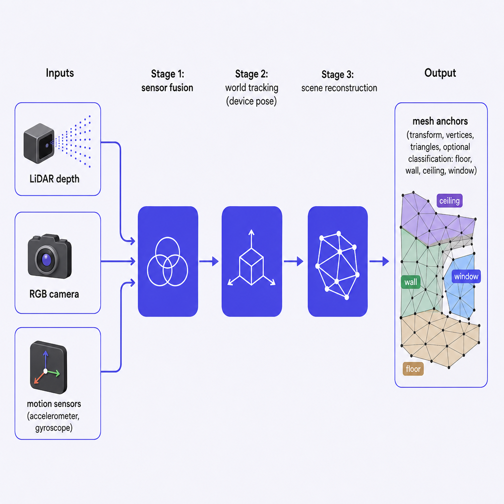
A useful surprise for anyone new to the API: ARKit does not hand you one enormous mesh. It produces multiple mesh anchors, each responsible for a portion of the scene. Every anchor carries a transform that places it in world coordinates relative to the device, vertex and index buffers describing the triangles of that patch, and optional classification data—floor, wall, ceiling, seat, door, window—when you request meshWithClassification instead of plain mesh. Together, these anchors form a continuously updated 3D model of the space around you.
This anchor-based design is what makes the mesh efficient to refine as you move. Instead of recomputing the whole scene, ARKit updates only the patches that changed, which is precisely why the reconstruction can stay live while you walk a room.
How ARKit mesh reconstruction works under the hood
Sensors: LiDAR, camera, and motion
On iPhone 12 Pro and later, the LiDAR Scanner emits infrared pulses and measures their return time to estimate distance to nearby surfaces. ARKit fuses those dense, near-field depth samples with the RGB camera feed and the phone's inertial sensors—accelerometer and gyroscope—to track the device's motion in 3D space.
This fusion is the pivot of the whole system. It lets ARKit know both what is in front of the phone (geometry and texture) and where the phone is, frame by frame, so successive depth samples can be stitched into a coherent model over time. If you want the sensor layer explained on its own, our breakdown of what the LiDAR Scanner in your iPhone can actually do covers it in depth.
World tracking and scene reconstruction
ARKit runs world tracking to estimate the device's pose in a stable world coordinate system. With sceneReconstruction enabled, it uses that pose to transform each new LiDAR depth frame into world space and incrementally builds a polygonal approximation of every surface it has seen.
Mechanically, depth samples become vertices, and ARKit connects those vertices into triangles to form a tessellated mesh. The system then splits that mesh across multiple anchors so it can refine parts of the scene without redoing all of it. If plane detection is also enabled, ARKit recognizes large flat regions and folds that information in, improving floors, walls, and tables and making them easier to snap to downstream. Our walkthrough of how LiDAR 3D capture works on iPhone traces the same flow from a capture-workflow angle.
Optional semantic classification
Beyond raw geometry, ARKit can classify mesh triangles by category, distinguishing a floor from a wall or a window. When you request meshWithClassification, it augments the anchors with labels indicating what each region probably represents. That semantic layer lets an app present cleaner interfaces—highlighting floors and walls separately, or filtering out non-structural surfaces before export—which matters for architecture, interiors, and robotics work.
Continuous updates as you move
As you walk through a space, ARKit keeps sampling depth frames and incorporating them into the world mesh. Revisit an area and the mesh densifies; enter a new region and fresh anchors appear. Because the mesh is live and approximate, ARKit is designed for interactive experiences—placing virtual objects, enabling occlusion—more than for static, millimeter-accurate surveys. We take that live stream and turn it into a stable OBJ or USDZ export suitable for reference, visualization, and downstream processing.
How Voxelio uses ARKit mesh reconstruction
Voxelio is built directly on Apple's ARKit stack and uses the LiDAR Scanner in Pro-class iPhones and selected iPad Pro models to drive every capture mode. In Mesh mode, we subscribe to ARKit's mesh anchors and continuously fuse them into a unified, textured 3D model anchored to the real-world coordinate system.
Here the division of labor is precise: ARKit's mesh reconstruction supplies the geometric scaffold of vertices and triangles, while our keyframe texture baking captures high-quality color from selected camera frames and projects it onto that geometry. We also run spatial point cloud fusion for users who prefer dense point clouds over meshes, and we store frame-accurate camera poses when you capture Pose+Video or MultiCam sequences for NeRF, SLAM, or photogrammetry pipelines.
All of this runs on-device. ARKit mesh reconstruction, point cloud fusion, and texture baking are computed on the phone, so no scan has to leave it to be processed. For professionals working with sensitive spaces—homes, offices, labs—that on-device boundary is often the deciding factor.
Mesh, point cloud, or pose data: choosing the representation
ARKit mesh reconstruction gives us a ready-made geometric representation with useful semantic hints, but it is not the only way to describe a scene. The same world tracking and depth estimation that generates the mesh also anchors point clouds and camera poses in a consistent coordinate frame, which is what lets Voxelio align these modalities spatially.
| Representation | Source | Best for |
|---|---|---|
| Mesh | ARKit-driven | Spatial understanding, occlusion, quick visualizations, OBJ/USDZ for design tools and AR |
| Point cloud | Voxelio fusion | CAD, reverse-engineering, and high-precision work where dense detail matters |
| Pose+Video | Voxelio capture | Camera trajectories and images to feed NeRF, SLAM, or custom reconstruction |
The practical takeaway is that a mesh compresses a scene into surfaces you can view and place objects against, while a point cloud preserves dense samples that a mesh may simplify, and pose data hands your own algorithm the raw ingredients. Choosing among them is a question of what your downstream tool actually consumes.
When ARKit mesh reconstruction is the right tool
ARKit mesh reconstruction is a strong fit when you need centimeter-level spatial precision rather than sub-millimeter tolerances, when semantic context adds value, and when real-time feedback matters so you can adjust your path instead of waiting on a post-processing step. It also shines when you plan to export textures and geometry into OBJ or USDZ formats that integrate naturally with design, visualization, and AR platforms.
You may prefer point clouds or pose data instead when you intend to run your own reconstruction pipeline and just need raw data with camera poses, when you are reverse-engineering or fabricating and precise dense sampling outweighs real-time interaction, or when you want to merge captures from multiple viewpoints with MultiCam before committing to a final surface.
In practice, many architects, interior designers, and real estate professionals find the ARKit mesh sufficient to capture as-built conditions visually and spatially. Engineers and CV researchers more often treat that same mesh as a fast preview or one layer alongside point clouds and pose sequences.
Risks and practical limitations
ARKit's mesh reconstruction is powerful, not magical, and knowing where it strains keeps you out of trouble.
Reflective and transparent surfaces—glass, mirrors, shiny metal—can produce noisy or incomplete depth readings that leave holes or distortions in the mesh. Moving objects and crowds are a second failure mode: the mesh assumes a mostly static scene, so people walking through the frame may appear as artifacts or vanish once ARKit re-estimates the surfaces behind them.
The LiDAR Scanner is also optimized for near-field depth rather than long-range scanning, so large exteriors or tall facades may need careful planning or multiple passes to cover adequately. And because the mesh is an approximation built for interactive AR features like occlusion and physics, it is not a legal survey or an engineering-grade measurement. For compliance workflows, treat Voxelio output as a spatial reference and confirm critical dimensions with traditional tools.
Weigh these constraints against your goal, and you can decide whether ARKit mesh reconstruction is your primary data source, a fast capture tool, or a complement to other methods in your stack.
Frequently asked questions
Which iPhones support ARKit mesh reconstruction in Voxelio?
ARKit's LiDAR-powered scene reconstruction works on Pro-class iPhones starting with iPhone 12 Pro, along with specific iPad Pro models that include a LiDAR Scanner.
How accurate is the ARKit mesh for professional work?
ARKit's mesh reconstruction delivers centimeter-level spatial precision, which Voxelio preserves through on-device fusion and export. That makes it suitable for architectural reference, interior planning, and many fabrication workflows, but not for sub-millimeter metrology.
Do my scans leave the device when Voxelio uses ARKit mesh reconstruction?
No. We run ARKit mesh reconstruction, spatial point cloud fusion, and keyframe texture baking entirely on the phone, so scans do not need to be uploaded to the cloud for processing.
What is the difference between Mesh and Point Cloud modes if both use LiDAR?
Mesh mode leans on ARKit's polygonal representation and semantic classification, giving you textured OBJ/USDZ models ideal for visualization and AR. Point Cloud mode fuses raw depth into dense colored PLY point sets, which are often better for CAD, reverse-engineering, and analysis.
Is ARKit mesh reconstruction suitable for NeRF, SLAM, or custom CV pipelines?
Yes, but most researchers use our Pose+Video or MultiCam modes to capture camera poses and images, treating ARKit's mesh as a convenient preview or auxiliary reference rather than the core reconstruction.