A 2,500-year-old clay tablet sits on a fieldwork table in southern Mexico. Twenty years ago, recording it would have meant a week of measured drawings, oblique-light photography, and caliper measurements that risked the surface every time a hand touched it. Today, a handheld structured-light scanner captures it in 15 minutes — every chisel mark, every crack, every grain of weathered clay encoded as a point cloud. This is the working reality of modern archaeology, and the shift it represents is not a documentation upgrade. It is a methodological reset. At Harvard's Peabody Museum, the Corpus of Maya Hieroglyphic Inscriptions program has digitized over 30 Maya sculptures from 10 archaeological sites, including the entire 64-step Hieroglyphic Stairway at Copan, Honduras — a monument so eroded that glyphs invisible to the naked eye are now legible through virtual raking-light manipulation, according to the Peabody Museum's Maya Corpus 3D scanning research program. 3D scanning has stopped being a tool that records what archaeologists find. It has become the lens through which they see what was always there.
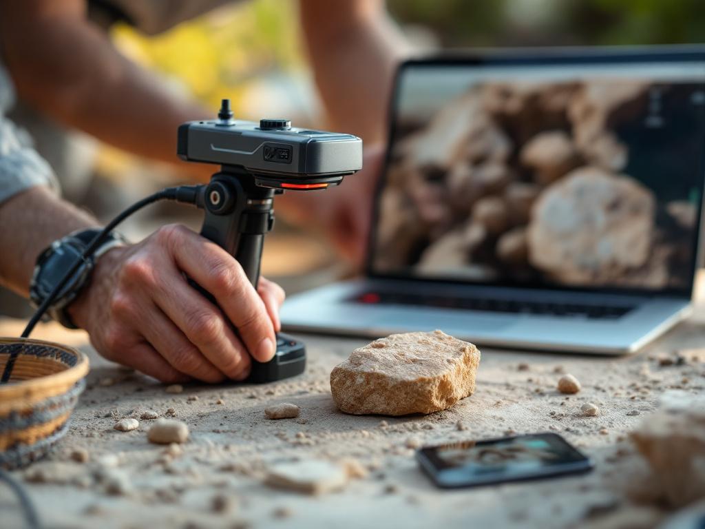
Table of Contents
- Why Manual Excavation Records Leave Permanent Information Gaps
- The Four Scanning Technologies Archaeologists Actually Deploy
- From Point Cloud to Publishable Model: The Six-Stage Processing Workflow
- What 3D Data Reveals That No Photograph Can
- Inside Real Field Campaigns: Three Programs That Defined the Method
- Where 3D Scanning Fails: Materials, Costs, and the False-Confidence Trap
- How Scanning Is Migrating From Excavation Into Adjacent Heritage Fields
- Building a Scanning Program: A Practitioner's Pre-Launch Checklist
Why Manual Excavation Records Leave Permanent Information Gaps
Traditional archaeological documentation has carried the same structural weaknesses for more than a century. The methods are not wrong — they are simply incomplete in ways that became visible only when 3D capture made the alternative possible.
Start with the constraints of the dig itself. Permits compress fieldwork into weeks. Rainy seasons close sites. Daylight runs out at 5 p.m. and lighting rigs draw too much generator power to run all night. Inside that compressed window, a skilled illustrator might need a full week to render a single sculpted stela from multiple angles — and the result is one person's interpretation of what the surface shows, not the surface itself. Photography helps but introduces its own failures. A photograph flattens depth into a single plane and fixes one lighting condition forever. Tool marks, chisel angles, and surface striations only become visible under specific oblique lighting, which means a single photograph captures one of dozens of legible states and discards the rest.
Then there is the handling cost. Every time an artifact is moved, measured with calipers, or repositioned for re-photography, micro-damage accumulates. Unfired clay sheds particles. Painted wood loses pigment to friction. Eroded limestone surrenders surface detail to the touch of a measuring tape. Conservators have known this for generations and have built handling protocols around it, but the protocols themselves slow documentation further — which sends teams back to truncated sketches and partial photographs.
An artifact documented only in photographs is a museum piece. An artifact captured in three dimensions is a research laboratory.
The deepest problem is irreversibility. When initial documentation is incomplete, the only recourse is returning to the site. That option vanishes more often than the field acknowledges. Sites are looted. Urban development paves over excavation areas. Conservation closures restrict re-entry for decades. Many 19th and early 20th century digs cannot be revisited at all — the artifacts went into private collections, the sites went under highways, and the only record of what was found is whatever the original team chose to draw. The Peabody Museum's Maya Corpus program exists precisely because earlier 2D documentation of glyphs has proven insufficient as the monuments themselves continue to erode in place. The original photographs and rubbings are still useful, but they were made when the surfaces were already partially lost and they cannot be redone with better lighting now that the surfaces are worse.
Traditional methods are not obsolete. They remain the right choice in several conditions. Remote sites without reliable power cannot run scanning equipment for sustained periods. Low-budget rescue digs operating on a 72-hour window before construction resumes cannot wait for processing pipelines. Communities that prohibit digital recording of sacred objects or ancestral remains have authority that overrides any technical capability. And every digital archive needs an analog backup against file-format obsolescence — paper drawings made in 1975 are still readable in 2024, while a 1995 digital scan in a defunct vendor format may not be.
The Society for Historical Archaeology has documented how 3D replicas now serve public archaeology functions — classroom kits, traveling exhibits, online study collections — that photography alone could never support. The shift toward digital capture is not a rejection of older methods. It is the recognition that history preservation requires more channels than any single century could deliver on its own.
The Four Scanning Technologies Archaeologists Actually Deploy
Field teams rarely commit to one scanning technology. They match the method to the question — and often run two or three methods on the same site within a single campaign.
| Method | Best For | Data Output | Range | Environmental Sensitivity |
|---|---|---|---|---|
| Photogrammetry | Wide sites, low-budget projects | Point clouds + color orthomosaics | Cm to km | Lighting-dependent; struggles with reflective surfaces |
| Structured-Light Scanning | Small-to-medium artifacts, fine detail | Sub-millimeter dense point clouds | Short range (<2 m) | Best indoors; sensitive to ambient light |
| Terrestrial Laser Scanning | Buildings, rock art, standing geometry | Highly precise point clouds | 1–300 m | Slow setup; weather affects accuracy |
| Airborne LiDAR | Landscapes, forest-covered sites | Point clouds + terrain models | Hundreds of meters | Penetrates vegetation; no color capture |
Structured-light scanning is the lab standard for artifact-scale work. The Peabody Museum's Maya program uses structured white-light projection at 0.055 mm resolution with a 90 mm field-of-view lens to record glyphs that have eroded beyond visual legibility. At that resolution, a single grain of weathered limestone is mapped as discrete geometry. The trade-off is range — most structured-light systems lose accuracy past two meters and require controlled lighting, which is why they tend to live in conservation labs and museum scanning bays rather than open-air dig sites.
Photogrammetry democratized the field. Any team with a DSLR camera and processing software can produce research-grade models, which is why the method now dominates rescue archaeology and lower-budget university digs. The accuracy is lower than structured light but the cost barrier is roughly an order of magnitude lower, and the workflow scales — a single photographer can document a site that would require a five-person scanning team to cover with structured light. The same dimensional accuracy that drives archaeological recording now drives commercial applications, including how 3D scanning improves e-commerce product accuracy for retail catalog work.
Terrestrial laser scanning sits between the two. It captures standing buildings, rock-art panels, and complex architecture at sub-centimeter precision over distances that would defeat structured light. Setup is slower — each scanner position takes 10–30 minutes — but the geometric fidelity for vertical surfaces is unmatched.
Airborne LiDAR redraws maps. The technology has rewritten the understanding of pre-modern urbanism in jungle environments, with the Angkor and Maya lowland surveys standing as the field's defining demonstrations. LiDAR penetrates forest canopy in ways that no other method matches, revealing road networks, terraces, and settlement patterns that ground survey would take generations to find. In practice, it does not replace ground-level scanning — it tells ground teams where to scan.
The hybrid approach is now the working norm. Major projects pair LiDAR for terrain, structured light for artifacts, and photogrammetry for mid-scale features within the same campaign, treating each as a channel rather than a competitor.
From Point Cloud to Publishable Model: The Six-Stage Processing Workflow
There is a time disconnect that surprises most people new to archaeological scanning. A structured-light scan of a single artifact takes 15–30 minutes in the field. Processing that scan into a research-ready model takes 2–6 weeks. The capture is the easy part.

Stage 1: Data capture and export. A raw point cloud contains millions of XYZ coordinates plus color values per scan. Common export formats include PLY (mesh-friendly), LAZ (LiDAR-compressed), and E57 (vendor-neutral). Format choice dictates which downstream software can open the file, which is why long-running programs standardize on neutral formats early. The Peabody Maya program captures every artifact from many overlapping positions to ensure no surface is missed — a single object can produce dozens of partial scans that must be combined later.
Stage 2: Noise removal and alignment. Stray points — dust particles, the operator's hand, background clutter — are filtered out. Multiple scans are then registered together using shared reference points or optical targets. In an interview hosted by scanner manufacturer EinScan, Prof. Maurizio Forte of Duke University noted that effective tracking during capture itself reduces this burden: "You don't waste time in a scanning session because you see that the signal or optical targeting is working well and that you don't miss the tracking." Catching tracking failures during capture is far cheaper than discovering them in post-processing two weeks later.
Stage 3: Mesh generation. The aligned point cloud is converted into a continuous triangulated surface. Density and smoothing parameters are chosen based on artifact complexity — too aggressive and tool marks vanish into the smoothed surface; too conservative and the file becomes unmanageable for downstream analysis. There is no universal correct setting. Conservators and analysts negotiate the parameters per object class.
Stage 4: Texture mapping. High-resolution photographs are projected onto the mesh to preserve color and surface condition. This step is what enables virtual raking-light analysis, where the digital light source can be repositioned to reveal carving details invisible under any single real lighting condition.
Stage 5: Segmentation and annotation. Features are tagged — breakage, tool marks, stratigraphic layers, glyph blocks. This is interpretive work, not mechanical processing. A scanner cannot decide where one stratigraphic layer ends and another begins. Metadata is embedded for database integration, which is the step that determines whether the model is reusable in 20 years or an isolated file no one can find.
Stage 6: Publication and access. The model is decimated for web viewing, and a high-resolution master is archived for analytical use — measurement, cross-section, virtual reconstruction.
Two practitioner notes. First, the open-source pipeline of CloudCompare and MeshLab handles most academic workflows; commercial platforms like Artec Studio and Agisoft Metashape dominate production environments where speed and support contracts matter. Second, raw scans must be archived even after the final processed model is published. Future analytical methods may extract more from the original data than current tools can — a lesson the field learned the hard way when 1990s digital archives lost their raw files and kept only the rendered outputs.
Scanning takes hours. Interpretation takes years. The technology compresses the first and expands the second.
What 3D Data Reveals That No Photograph Can
The research capabilities unlocked by 3D scanning are not incremental improvements on photography. They are categorically different. Each of the following is impossible — not difficult, impossible — with 2D documentation alone.
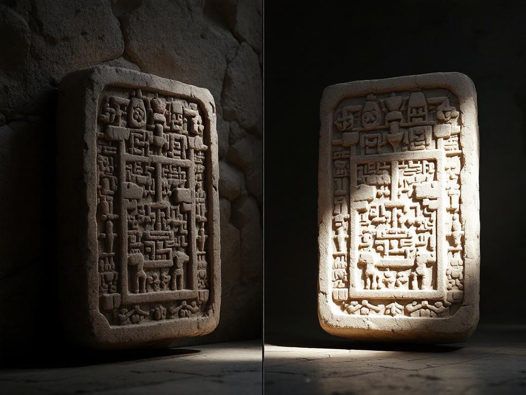
Tool marks and manufacturing techniques visible only under virtual raking light
Surface striations, chisel angles, and wear patterns become legible when a digital light source can be repositioned at any angle the analyst chooses. The Peabody Museum's Maya Corpus program cites this capability as central to its research mission — glyphs eroded beyond visual recognition under standard lighting are reconstructed by manipulating the virtual light direction across the captured surface. No photograph can replicate this. A photograph fixes one lighting condition permanently and discards every other angle that could have made the carving readable.
Volumetric and morphological measurement without physical handling
Vessel capacity, cranial volume, and the missing portions of fragmentary artifacts can be calculated directly from the digital model. Calipers and physical measurement risk damage and require repeated handling cycles; digital measurement is non-contact, infinitely repeatable, and produces results that other researchers can verify against the same model. The same artifact can be measured by a dozen analysts in a dozen countries without a single additional touch on the original.
Cross-comparison across sites and centuries
Identical scanning protocols allow direct metric comparison of artifacts excavated decades apart on different continents. Statistical analysis of point-cloud geometry can identify shared workshop traditions, technological transfers, and cultural variation invisible to qualitative typological comparison. The capability is most valuable for object classes — pottery profiles, lithic reduction sequences, sculptural canons — where small geometric differences encode meaningful cultural information that the eye cannot reliably catch across thousands of examples.
3D data lets you excavate infinitely — extracting new insights from the same digital scan years after the physical site has closed.
Reconstruction of damaged or destroyed monuments
Artifacts subsequently lost to natural disaster, looting, or conservation failure remain available for study through their scans. The Society for Historical Archaeology emphasizes this preservation-and-access function as a core public-archaeology benefit: 3D replicas extend research and educational access far beyond the physical original, and the digital archive survives events that the physical artifact does not. The same digital-twin logic now underpins broader cultural-heritage resilience strategies — see how 3D scanning supports disaster recovery and risk assessment at the institutional level.
Public access without site impact
Museums and research bodies grant remote access to scanned collections, enabling researchers in lower-resource countries to study artifacts they could never physically visit. This shifts the geography of archaeological scholarship. A graduate student in Lagos and a curator in Lima can examine the same Maya glyph at the same resolution as a Harvard postdoc — a redistribution of access that the physical artifact, locked in a Cambridge conservation room, could never produce.
Inside Real Field Campaigns: Three Programs That Defined the Method
Three programs illustrate how scanning has actually entered archaeological practice — not as theory, but as funded, multi-year work with documented outputs.
The Peabody Museum's Maya Corpus, Copan and Beyond
Harvard's Peabody Museum runs the Corpus of Maya Hieroglyphic Inscriptions program, which has digitized more than 30 Maya sculptures across 10 archaeological sites in Mesoamerica, including the full 64-step Hieroglyphic Stairway at Copan, Honduras. The team uses structured white-light projection scanning at 0.055 mm resolution with a 90 mm field-of-view lens, capturing each monument from multiple overlapping angles to ensure complete surface coverage.
The research payoff is direct: virtual raking-light manipulation now makes legible glyphs that erosion had rendered unreadable to the naked eye. The Hieroglyphic Stairway is the program's signature case — the longest known Maya hieroglyphic text, set in stone steps that have weathered for over a millennium. Recovering its content has required exactly the kind of high-resolution surface capture that no photograph could substitute for. The lesson for other programs is straightforward: when monuments are deteriorating in place, scan resolution becomes a race against weather, and the institutional commitment must extend across decades, not project cycles.
Etruscan Sarcophagi at Boston's Museum of Fine Arts
Prof. Maurizio Forte of Duke University led a 3D scanning campaign of ancient Etruscan sarcophagi at Boston's Museum of Fine Arts, working as part of a broader research program that integrates scanning with multispectral drone imaging and ground-based remote sensing. In an interview hosted by scanner manufacturer EinScan, Forte described his methodology: "My work is always at the intersection of classical archeology and digital methods for communication, dissemination, and data capturing. We usually integrate remote sensing applications, from drone multispectral with multispectral sensors or multispectral cameras and 3D modeling."
The campaign's value is methodological as much as documentary. Forte's team treats scanning as one channel in a multi-sensor recording strategy — not the primary deliverable, but one of several layers that, combined, produce a richer model of the object than any single method could deliver. The lesson: scanning rarely operates alone. Programs that treat it as a standalone capability tend to produce data silos. Programs that treat it as one input alongside multispectral imaging, ground-penetrating radar, and traditional excavation records produce integrated datasets that other researchers can actually use.
Public Archaeology and 3D Replicas (SHA Framework)
The Society for Historical Archaeology has documented how 3D replicas now extend archaeological collections beyond institutional walls — into classrooms, traveling exhibits, and online educational platforms. Unlike the prior two cases, this is not about a single dig. It is about what happens to scanned artifacts after the original research ends.
The shift the SHA documents is one of mission expansion. Scanning programs originally justified by research needs are now also justified by public-engagement outputs that extend the value of the data across decades and audiences. A scan made for a single research question in 2015 becomes a museum education resource in 2020 and a remote-learning asset in 2025, with each new use requiring no additional contact with the physical artifact. The lesson: the return on scanning compounds over time through reanalysis and public access, not through the original publication alone.
Cross-case takeaway. Three patterns repeat. Scanning is integrated at project design, not bolted on afterward. Success depends on hybrid sensor strategies, not single-technology bets. And the value of the data extends decades past the original campaign through reanalysis and public access. Teams that treated scanning as a checkbox produced data silos that no one opens again. Teams that built scanning into research questions from day one rewrote what their sites could tell us.
Where 3D Scanning Fails: Materials, Costs, and the False-Confidence Trap
Most published archaeological scanning literature is success stories. Failure modes are under-documented — and that itself is a problem readers should understand before committing to a program. The matrix below covers the limitations that recur across honest practitioner conversations, even when the published record stays quiet about them.
| Limitation | Why It Happens | Common Workaround | Residual Problem |
|---|---|---|---|
| Reflective surfaces (obsidian, glaze) | Scanner light scatters; voids in cloud | Matte spray; structured light over photogrammetry | Coating risks contamination |
| Translucent materials (amber, jade) | Light penetrates rather than reflects | Photographic record; resin-cast scan | Model represents a cast, not original |
| Vegetation or subsurface voids | Optical methods cannot see through soil | Pair LiDAR with ground-penetrating radar | Multi-sensor alignment error |
| File-format obsolescence | Vendor formats change in 10–20 years | Archive in PLY, E57; keep raw data | Long-term institutional commitment |
| Operator skill variance | Calibration and tracking discipline differ | Standardized protocols; training | Quality drift with staff turnover |
| Sacred or restricted objects | Scanning may be culturally inappropriate | Community consent; selective non-scanning | Digital democratization can override authority |
Four observations that the matrix alone cannot carry.
The false-confidence trap is the most common analytical failure. A high-resolution point cloud looks definitive. It is not. A million data points still require an archaeologist to decide what they mean, and novice analysts routinely over-interpret high-density scans because the visual fidelity feels like proof. The scan documents geometry; it does not document significance. A perfectly captured tool mark is still just geometry until someone with comparative knowledge identifies the tool that made it.
The vendor-evidence gap deserves direct acknowledgment. Almost all publicly available documentation of archaeological scanning is produced or hosted by scanner manufacturers — this article's own research base reflects that imbalance, with the Peabody Museum and the Society for Historical Archaeology among the few independent voices. Claims about speed, accuracy, and ease of use should be read with that context in mind. When you encounter a statement that scanning "works well" for a given material, the relevant question is who published the claim and what they were selling at the time.
The data-longevity problem is the quietest risk and the largest one over a 50-year horizon. A 2010 scan stored in a proprietary vendor format may already be partially unreadable in 2024. Long-term preservation requires active migration — moving data to current formats every five to seven years — not passive archiving on a server everyone has forgotten. The institutions that will still have usable scans in 2070 are the ones budgeting for migration now.
The accessibility paradox undercuts the democratization narrative. Scanning expands access to artifacts but concentrates interpretive authority among researchers with software access and training. Cheaper hardware does not solve this. The bottleneck is not the scanner; it is the processing pipeline and the tacit knowledge required to read a model intelligently. Genuine democratization requires partnerships and training programs, not just price cuts on equipment.
How Scanning Is Migrating From Excavation Into Adjacent Heritage Fields
The methods built for digital excavation are now spreading into adjacent fields that share archaeology's accuracy requirements. Three migration paths are worth tracking.
Disaster preparedness for heritage sites. Scanning programs originally built for documentation now serve as pre-loss baselines. When a monument is damaged by earthquake, fire, or armed conflict, the existing scan becomes the reconstruction blueprint. This shift — from documentation to insurance — is changing how heritage funding bodies justify scanning budgets. It is no longer a research expense alone; it is a risk-mitigation expense with a clear payoff in any catastrophic-loss scenario. The institutional logic increasingly mirrors how 3D scanning supports disaster recovery and risk assessment in built-environment contexts. The Society for Historical Archaeology explicitly frames 3D replicas as a public-good asset that survives the original.
Cross-sector method transfer. The same structured-light and photogrammetry pipelines used at Copan are now standard in industries that share archaeology's accuracy requirements: museum conservation, forensic anthropology, and increasingly, commercial sectors where dimensional fidelity is the product itself. The methods crossed over because they had matured enough to export. Manufacturing applications — from custom-fit consumer goods to 3D scanning in sustainable textile production — now use workflows that are directly continuous with what archaeological labs developed for artifact recording.
Public-engagement infrastructure. Scanned models published online turn dig sites into permanent classrooms. A model uploaded once can be downloaded by a researcher in Lagos and a sixth-grade teacher in Oslo in the same afternoon. The physical artifact stays in its conservation-controlled environment; the educational reach grows asymptotically. This is the part of the technology shift that has moved fastest in the past five years and that institutions are still under-tooled to manage.
In the EinScan-hosted interview cited earlier, Prof. Forte made a forward-looking observation that is worth taking seriously: "Museums will be dealing with an increasing amount of digital recordings over the next decade." The institutional infrastructure for managing those recordings — metadata standards, format migration policies, access protocols, rights frameworks — is still under construction. The scanning capacity is running ahead of the curatorial systems built to receive its output, and that gap is where the next decade of heritage-technology work will concentrate.
Building a Scanning Program: A Practitioner's Pre-Launch Checklist
The most common scanning-program failures are not technical. They are planning failures: budgets that did not account for processing labor, data plans built after data started arriving, and partnerships pursued too late. The checklist below addresses each. It is built for field directors, museum curators, and program leads deciding whether and how to integrate scanning into ongoing work.

- Define the research questions before selecting the technology. Surface analysis, volumetric measurement, and landscape mapping require different scanners. A team that buys hardware before specifying questions almost always discovers it owns the wrong tool — and discovers it after the procurement budget is already spent.
- Audit your artifact types for scan-compatibility. Reflective, translucent, and very small objects each have known failure modes. Map your collection against these categories before committing to one method. If 40% of your collection is glazed ceramic, photogrammetry alone will not serve you.
- Budget processing labor at 2–5× the scanning labor. A 30-minute scan generates roughly weeks of cleanup, meshing, texturing, and annotation. Programs that budget only for capture deliver unfinished archives — point clouds with no published models, sitting on servers no one opens.
- Lock the data management plan before the first scan. Storage capacity, naming conventions, metadata schema, format choices (PLY, LAZ, E57), and long-term archival commitments must exist before data starts arriving. Retrofitting a data plan onto an existing archive costs more than building it from scratch did.
- Plan for format obsolescence from day one. Vendor-neutral formats and active migration cycles — roughly every five to seven years — protect against silent loss. Raw scan data should be preserved alongside processed models, because future analytical methods may extract more than current tools can.
- Secure institutional partnerships early. University labs, conservation specialists, and visualization experts fill gaps cheaper than in-house hires. The Peabody Museum's Maya Corpus model is built on long-term institutional collaboration, not on vendor relationships, and the durability of its outputs reflects that.
- Run a pilot before scaling. Three to six months scanning 20–30 representative artifacts will reveal workflow bottlenecks and team skill gaps that no procurement spec sheet predicts. Pilots also generate the protocol decisions that will govern the full program.
- Document every protocol decision. Lighting setup, calibration method, scan overlap, target placement — every parameter chosen during the pilot must be written down. Staff turnover otherwise erases your standards, and the second generation of operators rebuilds protocols the first generation already solved.
- Build community and ethical review into the workflow. Sacred objects, ancestral remains, and culturally restricted artifacts require consent processes that precede capture, not justify it afterward. Scanning is not ethically neutral, and treating it as a technical question alone produces avoidable conflicts.
- Plan public access alongside research access. The Society for Historical Archaeology frames 3D replicas as a public-good asset, and the infrastructure for public viewing — web-optimized models, download licenses, educational metadata — should be designed in parallel with the research archive, not bolted on years later when the funding for it has already moved elsewhere.
A 24-month implementation sequence keeps the work grounded.
Months 0–6: Pilot. Rent equipment or contract a specialist. Scan 20–30 artifacts. Evaluate output quality and team fit before any procurement decision.
Months 6–8: Protocol freeze. Standardize parameters from the pilot. Document every decision. Build the metadata schema and naming convention. Lock the format choices.
Months 8–14: Soft launch. Deploy with the full team. Expect roughly a 20–30% efficiency loss during training as operators internalize the protocols. Identify bottlenecks — they will almost always be in processing, not capture.
Year 2 onward: Full integration. Scanning becomes a non-negotiable line item in every excavation or curation timeline. The program stops being a special initiative and becomes part of how the institution does its work.